The moon at sunse from Hurricane Ridge, Olympic National Park, Washington
We spent a day (well, technically it was a little over 24 hours) in Olympic National Park after we completed our Best of the PCT hikes and had a little time to spare. Since that was an ultralightweight trip, I only had my iphone with me, and so had to make do with it and capture some landscapes with a little creativity.
Sunset, Hurricane Ridge
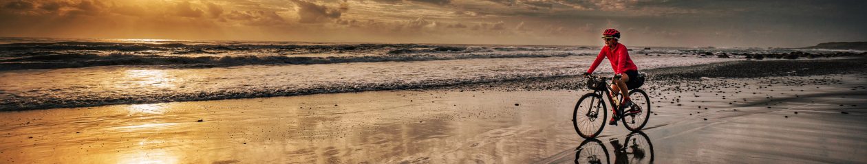
We drove out to the park in the evening after dinner, and hiked up Hurricane Ridge to catch sunset. An it was a gorgeous sunset, with all sorts of colors lighting up the sky, and no shortage of subject matter.
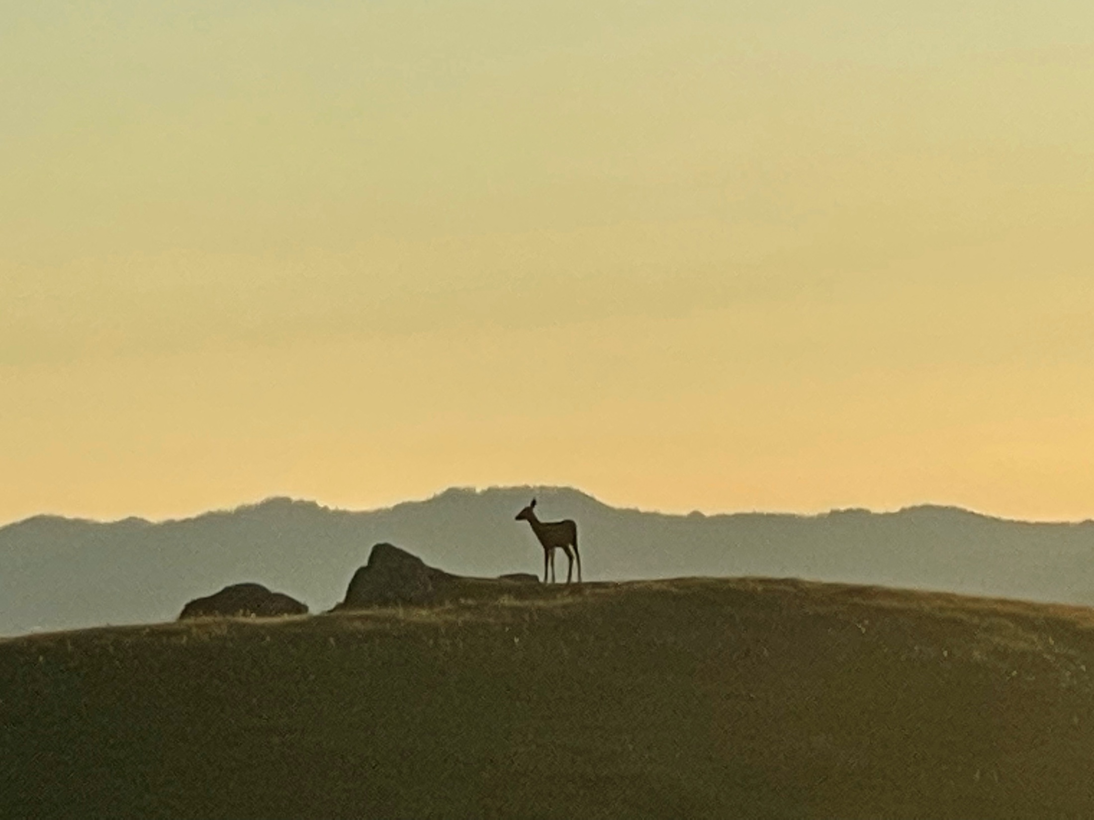
Deer on Hurricane Ridge at Sunset
I was on an ultralightweight backpacking trip, and so I only had my iPhone with me to take photos. These days, I’m finding less of a need to carry a lightweight camera with a small sensor, like my Sony RX100, and simply rely on the iphone’s camera on such ultralight trips. I still carry and use my full-frame Sony camera on less demanding trips, and when I want high quality output. I wrote about that here.
Hikers at Sunset on Hurricane Ridge
The iphone already works some magic into each shot, so I didn’t have to do much post processing. The key to getting great shots from my phone’s camera is to make sure the lens is clean. I wipe off the lens before each shot to make sure there’s no grease, sweat or water on the lens.
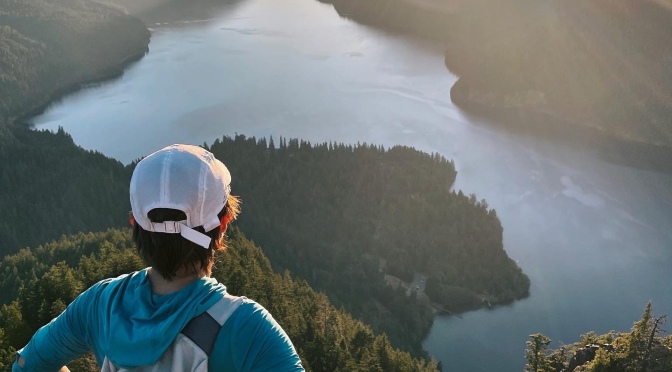
Looking towards the Pacific Ocean from Hurricane Ridge
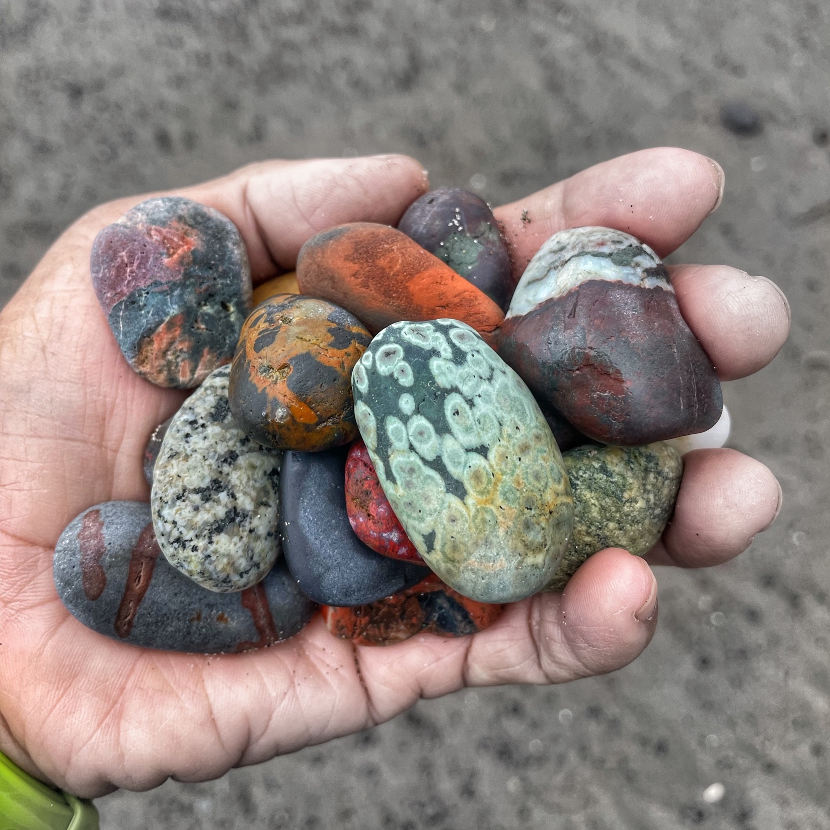
The next morning, we drove back into the park. Our intention was to visit the Hoh Rainforest, but there was a queue to get into the parking lot. We waited about 45 minutes, and it looked like there was still another hour to wait, so we bailed and headed out to Rialto Beach a little early. The tides worked in our favor as we took our time walking down to the Hole-in-the-Wall, looking at the multicolored stones the Pacific had washed in.
‘Hole in the Wall’ at Rialto Beach, Olympic National ParkPurdy colored stones washed up on the beach. Leave them on the beach please. I believe it’s illegal to remove them from National Parks.
After dinner, we hiked up Mt. Storm King to catch the sunset, and ended our visit to the Olympic National Park with a hike back down in the dark.
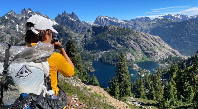
This was the last of our ‘Best of the PCT hikes’. We had a couple of days in Seattle before driving out to Snoqualmie. From the PCT parking lot just north of town, our intention was to take the Old PCT (Cascade Crest) trail down to Goldmyer Hot Springs, then make a loop by heading east and returning southbound on the new PCT trail across the Kendall Katwalk and back to Snoqualmie, a 55 mile (88.5km) loop.
But just a little way down from Red Pass, the Old PCT trail became to sketchy to continue, so we bailed on that and made it an out and on the PCT to Spectacle Lake and back. Caught some wind and rain on day 4, but thankfully, cleared up for our hike out on Day 5.
Looking down at Spectacle Lake, our home for the nightSwimming in Park Lake
How does this series of short hikes compare to a complete through-hike of the PCT? Well, Other than the commitment of being out here for much longer, and missing out on the experience of trail angels, trail magic, etc; the main difference was the speed, ease and amount of ground you can cover. Once I got my trail legs during my thru-hike, I tended to cover about 28 miles (45km) a day. That’s about 2-3 times the distance I covered on this trip. It meant I got to see a lot more in a single day on my thru-hike. If a thru-hike is a 4-year college education, then these series of hikes would be like taking a few night classes.
The Kendall Katwalk
It was a great trip, being able to revisit some beautiful places and share them with my wife and friends, given the limitations we had (driveable from an international airport, were loops, did not require advance booking of permits or require carrying abear cannister).
Since completing my through-hike of the Pacific Crest Trail in 2018, I had been looking for a way to share the experience with my wife. The idea was to find the most scenic parts of the trail that were driveable from an international airport, were loops, did not require advance booking of permits or require carrying a bear cannister. Click here for Part I.
Goat Rocks Wilderness
The Knife’s Edge, Goat Rocks Wilderness
The Knife’s Edge in Goat Rocks Wilderness had been one of the most scenic sections of my PCT thru-hike in 2018, and something that I had wanted to share with my wife. When we planned this trip, we had originally wanted to start with a 3 day hike in the here. It was close to Seattle and was inteded to be a shakedown hike with a number of options to shorten, if required. Lingering snow pushed us to to our most southern of our Best of the PCT hikes, The 3 Sisters Wilderness in Central Oregon, followed by the Timberline Trail.
Lots of snow near Goats Lake
After completing the Timberline Trail in Oregon, we had spent a day in Portland, and then a night in Packwood, from which we had driven to Walupt Lake to start our hike.
On the PCT in Goat Rocks Wilderness
From the Parking lot at Walupt Lake, we followed the Walupt Lake Trail east until it joined with the PCT. We then followed the PCT until the Knife’s Edge, then returned via the Lily Basin, Goat Ridge Trail and Klickitat trail to make a loop. We took 3 days and 2 nights, and it was really pretty, but it turned out to be a little tougher than we thought, as the Klickitat Trail was not well maintained.
Camp and dinner at Goat Lake
Photography Notes
All images in the Best of the PCT series were taken with my iPhone 12 Pro and edited on Snapseed and Darkroom. I’d taken my iphone to Germany on a bikepacking trip and had been quite satisfied with the convenience, ruggedness and weather proofing of the iphone. You can see that write-up and images here.
On the PCT, The Knife’s Edge, Goat Rocks Wilderness
My iphone camera and then my full-frame Sony a7c sees the most use. I rarely take out my Sony RX100 these days. I feel that the 1” sensor of the RX100 gets squeezed out. I either prefer the convenience and acceptable image quality of the iPhone, or put up with the weight and inconvenience of my full-frame Sony a7c with a couple of lenses for top quiality.
Since completing my through-hike of the Pacific Crest Trail in 2018, I had been looking for a way to share the experience with my wife. The idea was to find the most scenic parts of the trail that were driveable from an international airport, were loops, did not require advance booking of permits or require carrying abear cannister. Click here for Part I.
After a night in Bend, Oregon, we headed off to Mt Hood Village for the start of the Timberline Trail.
The Timberline Trail
Hiking the Timberline Trail around Mt Hood
We parked at The Timberline Lodge (check with the parking attendant where you are allowed to park) and immediately found the start of the trail, which was also the PCT, to start our 4-Day clockwise loop to circumnavigate Mt Hood. Self-issued permits are available about a mile into the trail.
Ramona Falls
On Day 1, we had to cross the Zigzag and Sandy Rivers, which had been difficult to cross during my 2018 thru-hike. This time, we managed to keep our feet dry crossing on both these crossings. In fact, with the aid of snow bridges and logs, some of our group managed to keep their feet dry throughout the hike!
The art of keeping one’s feet dry. I have short legs, so I opted for the safer option and got my feet wet. Timberline Trail around Bald Mountain
On Day 1, we detoured off the PCT and took the side trail to Ramona Falls. The falls and the subsequent side trail to get back to the PCT are definitely worth doing, and I did the same on my 2018 thru-hike of the PCT. We camped at Muddy Fork Creek for the first night. Somehow, we managed to separate ourselves from the rest of our group, but found them the next morning.
On Day 2, because of detours, we continued clockwise on the PCT, but where the PCT leaves the Timberline Trail and heads north, we took the option of heading south on the Timberline Trail around Bald Mountain, rejoining the Timberline Trail via the Cutoff Trail to continue our clockwise loop.
Near the highest point on the Timberline Trail Loop around Mt. Hood
The rest of the hike was pretty straight forward, until near the end of the hike, when we got to Elliot Creek. The creek crossing itself was ok, helped out by log bridges, but the descent to the creek bed was a bit gnarly. All in all, it was a great adventure and definitely one to put on the bucket list!
Crossing Elliot Creek. No, this isn’t sketchy at all!
Gear Notes
The Outdoor Research Echo Hoodie (women’s version here) has become my base layer of choice for biking and hiking activities. It is lightweight, versatile in that it shades from the sun, is relatively cool, blocks a bit of wind and yet is breathable.
The BRS 3000T remains my stove of choice. Cheap and ultralightweight, it needs to be used with a windshield to maximise its capabilities. I picked up a cheap titanium windscreen from Aliexpress.
Most of us used Hyperlite Mountain Gear backpacks. They are not the lightest, but I like them because they have an internal frame and the dyneema (cuben fiber) fabric is waterproof, and even though the seams are not sealed, I’ve found it waterproof enough for my needs that I don’t bother to use a liner. I like to use it paired with shoulder pockets. Mine are from ZPacks.
I started using the Klymit X Pillow after my Sea to Summit Aeros Ultralight disintegrated. It weighs less than 2 ozs and I quite like it. The trick to comfort is to blow it up, lie down on it, then let out air a little at a time until your head settles comfortably into is. Once it’s there, the pillow tends to stay in place rather than slip off my thermarest.
I’ve been wearing and liking the Inov-8 Trailfly G270 (formerly known as the Terraultra G270) trail running shoe for hiking. I’m off the Altra bandwagon. I love the wide toe box of the Altras, but the inconsistency of fit and sizing, even between successive generations of the same model have been driving me crazy. Compared to Altras, the toebox is narrower, even though Inov-8 says it’s their widest fit. Unfortunately, the fit tensd to be boxy, and the instep and heel are too wide for me, and I need to use an insole to take up some of that extra volume. The midsole, outsole and uppers of the G270 are generally much more durable than a typical Altra. The uppers don’t absorb much water, so tend to dry quickly, but I find them stiff and abrasive and need to wear the shoes with socks. One of the biggest advantages for me is that the Graphene-Grip outsole is super tacky, gripping wet rocks and roots (grip performance is similar to Vibram’s Megagrip), but it also lasts a long time.
Since completing my through-hike of the Pacific Crest Trail in 2018, I had been looking for a way to share the experience with my wife. The idea was to find the most scenic parts of the trail with the following requirements:
Accessible from an international airport
Did not require advance booking of a permit
did not require carrying a bear canister
a maximum of 5 nights out
loops to start and end at the car
Had to include part of the Pacific Crest Trail, obviously 😉
The 3 Sisters Loop, Oregon
We ended up selecting 4 hikes from Central Oregon up to Washington, and we called these, our ‘Best of the PCT’ hikes. These were:
Goat Rocks Wilderness, Washington, 3 Days
The 3 Sisters Loop, Oregon, 5 Days
The Timberline Trail, Oregon, 4 Days
North Cascades Loop, Washington, 5 Days
The plan was to fly into Seattle, pick up our rental car, drive to REI to buy canister fuel for our stove, some food, and get a Northwest Forest Pass, which is required for parking at the trailheads for most of the trails we were planning to hike. Then hit a supermarket, pick up the rest of the food and a mini Bic lighter. Then hit the road early the next day for the first trail.
The 3 Sisters Loop, Oregon
At the time I planned this in 2019, the 3 Sisters Loop did not require advance booking of a permit. It does now for certain times of the year. See this link for more information on when you need a permit and how to get one. Fortunately, we managed to snag one the week prior to the start of our hike when more permits are released.
We had wanted to start with another hike in Washington, but in mid July 2022, there was still a lot of snow on it, so we drove down to the southernmost hike on our list, the 3 Sisters Loop, near Bend, Oregon.
Starting the hike on the morning of Day1
This turned out to be a pretty good shake-down hike. Not too much elevation change and still a lot to see. We parked and started our hike from the Lava Lakes Camp Trailhead. That was the shortest drive from Bend, but as it’s a loop hike, there are a number of options on where to park and where to start.
Day 1, Creek Crossing with dry feet
We decided on an anticlockwise loop, so the first day was spent hiking through a lot of dead trees, a few ‘feet dry’ creek crossings, and fighting mosquitoes. We ended the day with a nice campsite next to Alder Creek.
Enough mosquitoes for you?
For us, it was a 5 day hike, and the scenery started looking better from Day2. We eventually connected with the PCT near the southernmost point on the hike and followed that all the way back to the car.
Morraine Lake on Day3Views of Mt Washington, 3 fingered Jack, Mt Jefferson, and Mt Hood on Day4
After the hike, we drove back to Bend for a couple of days rest before heading out for the next hike.